Where rivers run uphill
Three scientists travel to Antarctica to explore a secret world hidden beneath the ice.
 |
|
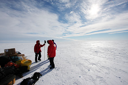
A team of scientists prepares to camp on the West Antarctic Ice Sheet to study lakes and rivers beneath the ice.
|
| Douglas Fox |
The snowmobile bucks like a mechanical bull as it bounces over a mound of ice. I squeeze the throttle and zoom forward, trying to catch the two snowmobiles in front of me. My fingers are numb with cold, despite the puffy black Darth Vader-style gloves I’m wearing.
It’s –12º Celsius, a beautiful summer afternoon in Antarctica, just 380 miles from the South Pole. We’re in the middle of a huge blanket of ice, called the West Antarctic Ice Sheet. This ice sheet is half a mile thick and covers an area four times the size of Texas. The sun glares off the ice, and through my goggles the ice takes on a silvery-gray sheen.
 |
|
At a remote air base on the West Antarctic Ice Sheet, the tiny Twin Otter plane refuels before ferrying the team back to McMurdo Station for the trip home.
|
| Douglas Fox |
Several days ago a tiny airplane landed on skis and dropped us off with a pile of boxes and bags. We’re camping in tents on the ice for three weeks. “It’s exciting to be here, 250 miles away from the nearest people,” said Slawek Tulaczyk, the guy who brought us here. “Where else on planet Earth can you do that anymore?”
Tulaczyk’s name looks like scrambled alphabet soup, but it’s easy to say: Slovick Too-LA-chick. He’s a scientist from the University of California, Santa Cruz, and he has come here to study a lake.
Maybe that sounds strange, looking for a lake in Antarctica. Scientists often call this place a polar desert, because despite its thick layer of ice, Antarctica is the driest of the continents, with very little new snow (or water in any form) falling each year. So dry is Antarctica that many of its glaciers actually evaporate rather than melt. But scientists are starting to realize that another world lies hidden beneath Antarctica’s ice: rivers, lakes, mountains and even volcanoes that human eyes have never seen.
Tulaczyk, two other people and I are far from camp, zooming on snowmobiles toward one of those hidden lakes. It’s called Lake Whillans, and was discovered only a few months before our trip last summer. It was found by remote measurements taken from a satellite orbiting the Earth. We are the first humans ever to visit it.
Guided by satellites
Scientists think that lakes under the ice might act like giant slippery banana peels — helping the ice slide more quickly over Antarctica’s bumpy bedrock toward the ocean, where it breaks into icebergs. It’s a lovely theory, but no one knows if it’s true. In fact, there are many basic things that we don’t understand about how glaciers work. But it’s important to find out because only if we understand the basic rules that Antarctica’s ice sheets live by can we predict what will happen to them as the climate warms.
The West Antarctic Ice Sheet contains 700,000 cubic miles of ice — enough to fill hundreds upon hundreds of Grand Canyons. And if that ice melted, it could raise sea levels by 15 feet. That’s high enough to put much of Florida and the Netherlands under water. Understanding glaciers is a high-stakes game, and that’s why Tulaczyk has brought us all the way to the bottom of the world to test whether lakes really do act like banana peels under the ice.
We’ve been riding toward Lake Whillans for six hours now. The scenery hasn’t changed a bit: It’s still big, flat and white in every direction as far as you can see.
Without any landmarks to steer your snowmobile by, you could easily get lost forever in a place like this. The only thing that keeps us on track is a walkie-talkie–sized gadget, called a GPS, mounted on the dashboard of each snowmobile. GPS is short for Global Positioning System. It communicates by radio with satellites orbiting Earth. It tells us exactly where on the map we are, give or take 30 feet. An arrow on the screen points the way to Lake Whillans. I just follow that arrow and hope the batteries don’t run out.
Uphill squirts
Suddenly, Tulaczyk raises his hand for us to stop and announces, “Here we are!”
“You mean we’re on the lake?” I ask, glancing around at the flat snow.
“We’ve been on the lake for the last eight kilometers,” he says.
Of course. The lake is buried under ice, two Empire State Buildings below our feet. But I’m still a tiny bit disappointed not to see any sign of it.
“The surface of the ice is boring,” says Tulaczyk. “That’s why I like to think about what’s below.”
The world half a mile below our feet is pretty weird. We all know that water runs downhill. It always does — right? But under Antarctica’s ice, water can sometimes run uphill.
Under the right conditions, a whole river can spurt from one lake uphill to another lake. That’s because the ice weighs so much that it presses down on the water with thousands of pounds of pressure per square inch. That pressure is sometimes strong enough to force the water to squirt uphill.
I help Tulaczyk and his graduate student, a 28-year-old named Nadine Quintana-Krupinsky, loosen the ropes on a sled that we towed here. We unload boxes and tools. Quintana-Krupinsky pounds a pole into the ice. Tulaczyk opens a plastic case and fiddles with some wires inside.
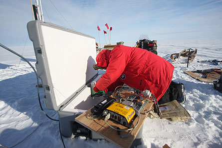 |
|
Tulaczyk installs “Cookie” — our first GPS station — to track movement of the ice on top of Lake Whillans for the next two years.
|
| Douglas Fox |
The thing in that plastic case will help Tulaczyk spy on this lake, through the half mile of ice covering it, for the next two years.
The case contains a GPS that’s way more accurate than the ones on our snowmobiles. It can feel the ice move by as little as half an inch. The GPS will track the ice as it slips toward the ocean. Previous satellite measurements have revealed that the ice here moves about four feet per day. But those satellite measurements are scattered: They were only taken a few days per year, and only on some years.
What’s special about Tulaczyk’s project is that his GPS boxes will take continuous measurements for two years. And unlike satellites, the GPS boxes won’t just measure forward movement. They will simultaneously track the ice rising and falling, which it does because it’s floating on top of Lake Whillans, like an ice cube floats in a glass of water. If more water flows into the lake, the ice is pushed up. And if water spills out of the lake, the ice drops.
Cookie and chatterbox
Satellites have watched from space as the ice floating on Lake Whillans rises and drops by 10 or 15 feet. In fact, this is how Lake Whillans was first discovered a few months before our trip.
A satellite called ICESat that uses a laser to measure the height of the ice found that one section of ice (maybe 10 miles across) was constantly rising and falling. Helen Fricker, a glaciologist at the Scripps Institution of Oceanography in La Jolla, California, thought there was a lake hidden beneath the ice there. She and Benjamin Smith, of the University of Washington in Seattle, have used this way to find other lakes, too. “We’ve found about 120 lakes so far,” said Fricker on the phone, back in California.
Unfortunately, ICESat only measures the lakes 66 days per year. So now that the lakes have been spotted from afar, the next step is to spy on them more closely — which is why we’re braving the cold.
Over the next two years, Tulaczyk’s GPS will measure forward movement and up and down movement of the ice at the same time — something satellites can’t do. This will show whether movement of water into or out of Lake Whillans causes the ice to slide more quickly. It’s an important step toward understanding how water gushing through those rivers and lakes controls the movement of the whole West Antarctic Ice Sheet.
Tulaczyk and Quintana-Krupinsky take two hours to set up the GPS station. We’ve named it Cookie, after one of Tulaczyk’s young daughters. (Another GPS station that we’ll install in a few days is nicknamed Chatterbox, after Tulaczyk’s other daughter.) Once we leave Cookie behind, it must survive two winters on the ice. The sun will not shine for four months each winter, and the temperature will drop to –60 ºC. That kind of cold causes batteries to die and electronic gadgets to go on the fritz. To deal with it, Cookie the GPS has four 70-pound batteries, plus a solar power collector and wind generator.
As Tulaczyk and Quintana-Krupinsky tighten the last screws, a cold breeze spins the propeller on Cookie’s wind generator.
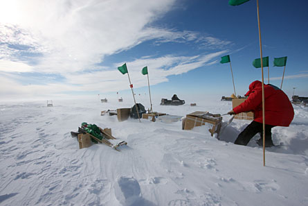 |
|
Tulaczyk digs equipment out after a storm buries the camp in snow. Flags mark the positions of objects so that they can still be found after being buried in snow.
|
| Douglas Fox |
By the time we rumble back into camp on our snowmobiles, our jackets and face masks are covered in frost. It is 1:30 a.m. as we unload our snowmobiles. The sun is shining bright. In Antarctica during summer, the sun shines 24 hours per day.
Peering through the ice
We ride snowmobiles up to 10 hours per day as we visit Lake Whillans and several other lakes in the area.
On some days I work with the fourth person in our group, Rickard Pettersson, a glaciologist from Uppsala University in Sweden. He tows me behind the snowmobile on a sled that also holds a rugged black box — an ice-penetrating radar. “It will transmit a 1,000-volt pulse, 1,000 times per second, transmitting radio waves down into the ice,” he says as we get ready to go. The box will listen as those radio waves echo off the bed of the ice.
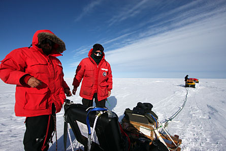 |
|
Tulaczyk (left) and Pettersson (right) with the ice-penetrating radar.
|
| Douglas Fox |
For two hours, Pettersson expertly guides the sled over every single ice bump in our path. A couple of them nearly send me tumbling. I hold on, and stare into a small computer screen as it bounces up and down.
A jagged line meanders across the screen. That line shows the ups and downs of the landscape half a mile below, traced by radar.
Some of these radar traces reveal low spots in the ground under the ice. They might be rivers connecting one lake to another, Tulaczyk says one night at dinner. He and Quintana-Krupinsky install GPS stations above some of these spots, in hopes of catching the ice rising and falling as water spurts through the rivers.
Within two years, the GPS stations that Tulaczyk leaves behind will hopefully collect enough information for him to start to understand how water controls the ice’s slide toward the ocean.
But the lakes hold other mysteries, too: Some people believe that unknown forms of life lurk in the dark waters beneath Antarctica’s ice. Scientists hope that studying whatever dwells in the lakes — whether single-cell bacteria or something more complex — will help them understand what kinds of life might survive in other worlds. On the top of that list of other worlds is Jupiter’s moon Europa, where an ocean of liquid water may slosh beneath a crust of ice many miles thick.
Tulaczyk hopes to drill through Antarctica’s ice to Lake Whillans in a few years and sample the water to find out for sure what kind of life dwells there. “It’s fascinating,” he says, “to think that there’s a whole continent underneath, imprisoned by a layer of ice.”